|
Heybridge Basin (Cannibal
Island) |
|
|
Floods & Local Sea
Defences |
|
|
|
The sea defences of the
English coastal districts for hundreds of years came under the
authority of a specialist government agency. Unfortunateley at
sometime during the 1960's this was transferred to the control
of the local district councils. Ands so began a period of 'make
do and mend' with seemingly little background knowledge on the
situation. During the 1980's when the first development began
on the land previously of May & Butcher, Colin Brookes formed
a small group to make the MDC aware of the looming problems the
work would be causing. The people involved in the development
were unaware of the difference between drains and open flood
ditches. Along the innerside of the seawall there were open flood
ditches which were having pipes set in and covered over as drains.
The council were unaware that the ditches were designed to take
any initial surge of water from either over or through the seawall
and distribute it away. The protest was ignored and most of the
emergency flood ditches have now been covered over. For many
years the seawall consisted of large rocks set in an earth and
ballast wall. Later the seawall was refaced with large concrete
blocks set in pitch or tar. And finally it was topped off with
a concrete low wall in the most vulnerable places. |
 |
|
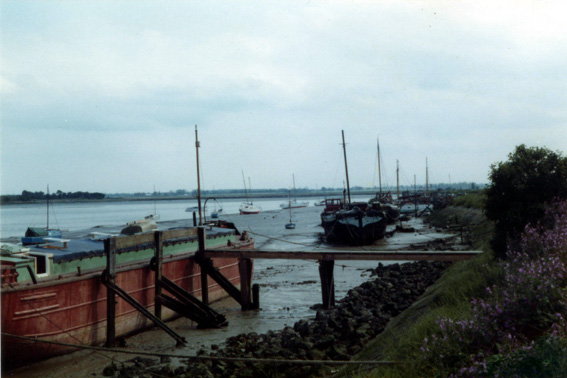
(above) Sadly as this picture taken in 1978 shows, that
when refacing the seawall with concrete the old rocks were often
just rolled down to the beach and left, which ultimately ruined
many waterfront areas. |
|
 |
|
(above) The refaced seawall with it's extra topping wall
on the village frontage. |
|
|
|
|
Tidal
Waves & Floods in the Village |
|
1874 |
|
On the 23 March 1874,
the tide was extremely high, causing the canal to overflow and
flooding parts of the Basin to a depth of 2 or 3 feet. The then
landlady of 'The Exchange', Emma Joslin, despite being assured
her 3 children were safe with a neighbour and urged to retreat
upstairs to safety. was found drowned at the foot of the stairs.
The coroner said it was painfully clear that she must have fallen
from the joint effects of drink and excitement, and the jury
returned a verdict of accidental death. |
|
|
|
1928 |
|
From an article in the
'Essex Weekly News' of January 1928. Tidal Wave In Essex. Boats
In The Street. In the village of Heybridge Basin water poured
over the sea walls and canal banks, and quickly rose to a dangerous
height. Upwards of 30 houses were flooded. Milk and bread were
delivered by boat on Saturday morning, and in some cases food
was delivered to villagers through their bedroom windows. Two
women living in a Basin bungalow climbed on to the roof with
a candle and remained there for several hours. Mr S.J.Purkiss
of Heybridge Basin Post Office, told our reporter that the bulk
of the water that flooded the village came from the Canal. The
lock gates he said were forced open by the tide, causing a tremendous
rush of water, and the canal banks being lower than the sea wall
the water overflowed from the canal. Basin Pilot Mr Austin who
has lived in the village all his life, expressed the opinion
that the village would have escaped the flood if the canal banks
had been built higher. |
 |
|
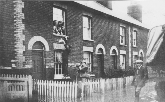
(above) January 1928. A postcard of this bock of four
terraced cottages pictured the flood of 1928. The photo features
Rose Cottage, and shows food being handed up to a woman and her
children in Rose Cottage, who had taken refuge upstairs. |
|
 |
|
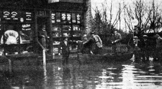
(above) January 1928. Postal and urgent deliveries being
made by boat to Sam Purkiss's Store. |
|
|
|
|
During the 1928 flood 'Mucker' Clark's wife 'Dinee',
was found floating on a mattress on top of a wooden table in
'Rat Hall'. |
 |
|
(above) 'Rat Hall' almost awash on a high tide. |
|
|
|
|
1953 |
|
On the night of Saturday
31 January 1953 a severe storm coincided with a high spring tide
in the North Sea, and the resulting tidal surge caused great
devastation all along the east coast. In eastern England 307
people were killed, 120 of them from Essex. There was a major
breach in the sea wall just the other side of the Osea Road opposite
'Decoy Farm'. The water poured through this breach and flooded
a huge area behind the sea wall from Goldhanger to the Basin,
with the Millbeach Camp Site suffering most damage. The breach
was so wide that it has never been repaired, a large loop of
new sea wall having been built on the old farmland round behind
it. |
 |
|
(above) Basin Road the day after the January 1953 flood. |
|
 |
|
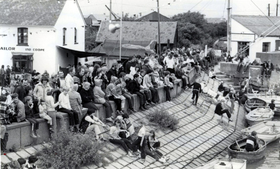
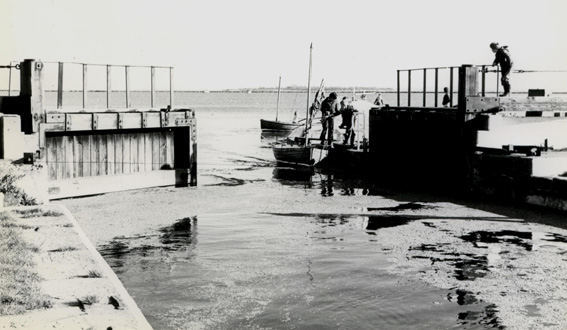
(above
& below) 1970's. An exceptionally
high tide enabling all the canal gates to be opened at the same
time when levels were equal. Pictured are the Basin kids (Phil
Polden and Peter Brookes) who took advantage of the unusual situation
and rowed their boats in and out just for fun. |
 |
|
|
|
|
Until the sea wall was built
higher, properties in the village were frequently prone to flooding
during high tides, thankfully no longer an issue in The Basin,
but those of us who live in the older properties are used to
the accumulated salt which shows up from time to time up to almost
4 ft around the downstairs rooms in Basin Road cottages, boarded
over under the wallpaper. In earlier times even with very limited
finances and equipment there was a greater understanding and
placement of protection for the sea defences. Large open drainage
ditches were built on the inside of the seawall to hold an initial
mass of water from either a surge or break over the wall, this
would give the villagers a short time to prepare for the worst
if it came. Inexperienced city developers and architects thought
it would be an improvement to health to have them covered over.
The villagers were also very aware of the seasonal very high
tides and changes. About 1910 a heavy marker post was set in
the beach opposite the 'Jolly Sailor', known as 'The 9ft Post'.
The post remained in situ for some years before being broken
off and not replaced. |
 |
|
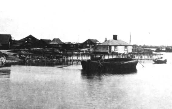
(above)
'Mucker' and 'Dinee' Clark's house
(Rat Hall). The ballast barge 'Billy Boy', with the '9ft post'
clearly visible just behind it. |
|
|
|
|
Flooding
in the village has not only been from surge tides or breaks in
the seawall but also from internal sources such as heavy sudden
or continious rainfall. The drainage system of the village for
rainfall and clean water at this time, is via an exit drain through
the seawall to a steel door control sluice on the seaward side
between 'Muckers Island' and the 'Newham' centre. The doors open
when water is forced out from the village but when the pressure
of the tide reaches the doors from the seaward side they are
closed. However on several occasions these doors have remained
blocked open on a high tide and water has flooded in to the village,
rising in Basin Road just along from the 'Jolly Sailor'. |
|
|
|
1989 |
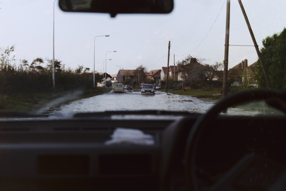 |
|
(above) October 1989.
Goldhanger Road at the bottom of Basin Road. |
|
|
|
When the land that was May & Butcher's was
being developed in to the new 'Maritime' housing estate, Colin
Brookes noted that the developers were filling in the main flood
protection ditch for the village, and converting it to a drainage
ditch partly with the use if the funnels from 'HMS Dido'. He
made an official complaint to the Maldon District Council pointing
out the difference between open top 'Flood Ditch's' and enclosed
'Drainage Ditch's'. Shortly afterwards a new flood siren alarm
system was set up and Colin was interviewed raising his concerns
on Anglia Television News. But with the rising waters of the
North Sea, and the control of coastal defences now transferred
away from the Government to the local area Councils, who knows
what the future holds. |
 |
 |