|
Heybridge Basin (Cannibal
Island) |
|
|
Click
on underlined blue names for link to more details |
|
|
Major
Early Property & Landowners |
|
For many years much of the village
and area surrounding it was rented by it's inhabitants from the
Canal Company and Joseph Going, and to a much lesser extent John
Sadd. The map below can give a good idea of the property held
by these three owners in the first 50 years. Joseph Going sold
much of his assets in the area in the 1870's, with the Canal
Company selling all their property in 1919, except for along
the immediate sides of the Basin and the Canal. |
 |
|
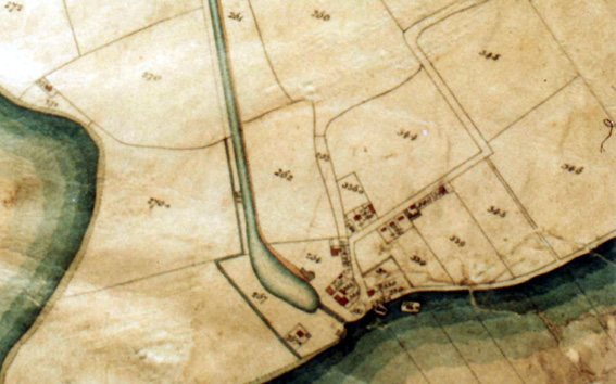
(above) part of the earliest
official land survey map of Heybridge Basin. It shows the first
stage of development with the buildings in place and areas of
ownership. |
|
|
Chelmer
& Blackwater Canal Company |
|
The company owned areas
marked on the O.S. map .... 262, 264, 265, 267, 268, 330, 331,
332, 333, 333A. Occupied by the following .... The 'Jolly Sailor',
the 'Chelmer Brig', the 'Bergholt Arms', Robert Blatch, Henry
Clarke, John Woodcraft, James Clarke, William Chaney, Richard
Going, John Parker, William Huby, George Rudland, James Hardy,
Sam Saxby, Robert Chaney, Hannah Smith, John Clarke, Tom Warraker,
James Porter, Thomas Balls, Dinah Clarke, Sampson Wright. |
|
Joseph Going |
|
Joseph Going owned areas
marked on the O.S. map .... 239, 240, 243,244, 341. |
|
John
Sadd |
|
John Sadd owned areas
marked on the O.S. map .... 334, 335, 338. these contained the
coalyard that Richard Going rented, the land and the Chapel that
was sited on it, the land on the other side of the lane which
included 'Anne Joslin's Beerhouse', Nos 8 to 12 Basin Road occupied
by Thomas Russel, William Crawley, James Tinmin, John Blatch. |
 |
 |