|
Heybridge
Basin (Cannibal
Island) |
|
|
Click
on underlined blue names for link to more details |
|
|
An Outline History |
|
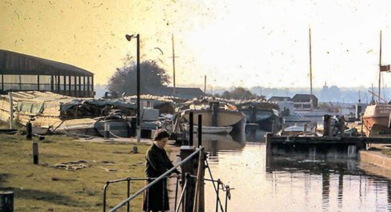
'Heybridge Basin', is
a small village which has developed over the years around the
entrance to a canal entered via a lock from the East Coast Estuary
of the River Blackwater. The nearest village is called 'Heybridge',
the canal is the 'Chelmer & Blackwater Navigation'. The 'Basin',
is an extended area of water just inside the entrance to the
canal where large vessels can be moored and turned, unloaded
and serviced. |
|
It's origin began in 1765
with a proposal to make the River Chelmer navigable from Chelmsford's
Moulsham Bridge to Maldon Bridge. However due to opposition from
Maldon business operators this project was abandoned. In 1793
Parliament passed the act for the making and maintaining of the
Chelmer & Blackwater Navigation, bypassing Maldon with the
use of a modified section of the River Blackwater and a new canal
cut through Heybridge falling in to the Estuary via a lock opposite
Northey Island. |
 |
|
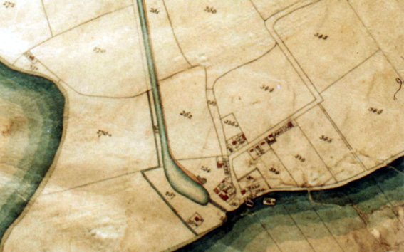
(above) part of one of
the earliest official land survey maps of Heybridge Basin. It
clearly shows an early stage of development with buildings in
place or not inplace, this contradicts the claims of several
current officialy publicised documents, pamphlets, local websites
and books. |
|
|
Prior to the completion
of the canal there was very little development in the area generally
known as 'Boro or Barrow Marsh'. A 'Salt Pan' and salt supply
business was operated by a Mr Tovee in an area just behind the
present Lock House, and another 'Salt Works' was operated from
where the Blackwater Sailing Club now
stands. The lake in the field of the Sailing Club was originally
the main 'salt pan', and the mound nearby was always described
as the the heaped spoil from when it was dug. There have been
claims of it being a 'Barrow' (burial mound), but as this area
was regularly flooded and underwater in earlier times (remnants
of the earliest sea defence wall are still visible further back
on the other side of Basin Road), it is not logical that in times
past it would have been used as a burial area, however this will
undoubtedly continue for many years as a point of contended discussion.
The burial area giving it's name to 'Barrow Marsh' and 'Barrow
Marsh Farm', is on the other side of Goldhanger Road. The two
sections of road named 'Boro or Barrow Road' leading from Goldhanger
Road through the village as far as the seawall were defined in
the 'Enclosures Act' of the 7th December 1815. The first section
from Goldhanger Road reached as far as what is now the 'Tinkers
Cottage'. It is from this point that the village started and
the new road name of 'Basin Road' was assigned, it's changes
also defined in the 1815 Act. Later the name 'Boro or Barrow
Road' was dropped and the whole length from Goldhanger Road to
the seawall by the 'Jolly Sailor' pub took on the same name of
'Basin Road'. |
 |
|
(above) What is believed to be the remains of the original
salt pan operated by Mr Tovee can still be seen just to the right
of 'Navigation Cottage' at lower right. |
|
 |
|
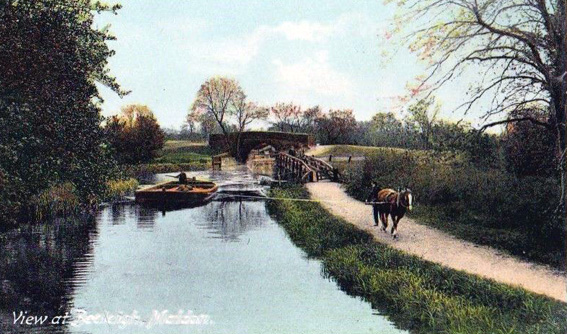
(above) a horse on the
tow path hauling a barge (or lighter). The horse was later replaced
by a large outboard motor mounted on the stern of the barges. |
|
|
The Basin and canal was
completed in 1796 and the first dwelling of the new village was
built near the spot later used for the Eel
Company building. This cottage was used as the home and office
of the first Lock Keeper and Harbour master who collected the
tolls and revenue. Navigation from the Basin lock via the canal
was finaly linked to the river section to Chelmsford, and opend
a year later in 1797. The spoil dug out from the building of
the lock was dumped outside, at first being an island linked
by a bridge (often referred to as 'Muckers Island'), but later
developed with a permanent link to it and now a boatyard, tea
rooms and marina. Over the years the Basin has gone through four
different periods of main use creating a matching development
and growth of it's dwellings and inhabitants. For many years
it was almost completeley self contained with it's residents
rarely venturing outside other than by water. |
 |
|
(above) barges loaded with coal waiting to be hauled to
Chelmsford. Note that the tow path for the horses is only on
the South side of the canal for the whole navigation. |
|
|
The first to make use
of the direct link from the sea to Chelmsford were the coal merchants
shipping down from the Tyne. They sailed down heavily laden with
coal in what were known as 'Collier's', usually 'Brig's. Some
unloaded in the Basin on to barges which were then horse-drawn
to Chelmsford, but most lay at anchor out in the Blackwater and
unloaded on to barges there in 'Colliers Reach'. Coal was unloaded
from the ships in to barges by a method known as 'whipping' (three
men jumping on a long plank). We know from an earlier map published
before the canal was built that this section of the Blackwater
was already called 'Colliers Reach'. Colliers could be seen anchored
all along the reach for many years before the Canal opened, when
the coal was destined for Maldon and the route inland from there.
Vessels returning empty had to take on a certain amount of ballast
to ensure their continued stability under sail, some used mud
from over the Northey shore, but most loaded aboard sand and
shingle ballast from the corner area opposite Hillypool Point
which could also sometimes be sold on. After years of taking
this ballast from the same place a large area developed which
became known as 'The Ballast Hole'. A wealthy ship owner called
Joseph Going saw the potential of the
area from the very begining, and invested heavily in the development
of the supply of coal and other goods to Chelmsford via the canal.
He built a large warehouse at Heybridge which became known as
Going's Wharf. He owned and built barges and other craft at the
village as well as buying up property and constructing many buildings
throughout the village including the barn now converted to the
'Barn House', and even a beer house (the 'Chelmer Brig'). His
son continued the coal business in the village for some years
after from a yard opposite the 'Exchange'. |
 |
|
(above) barges loaded with timber and prepared wood awaiting
transfer to 'Brown's' in Chelmsford |
|
|
With the advent of the
railways and the change in the prevailing wind on the East Coast,
the days of sail and the Collier's slowly dwindled. There followed
a period of very lean years in shipping, many of the businesses
that had thrived in the village supplying all their needs including
beer from the seven drinking establishments, closed. The canal
company sold off much of the land it owned and moved the Lock
Keeper in to the building what is now 'The Old Ship' pub. A new
trade eventually moved to the Basin operated by 'Brown
& Son Ltd', the importation of timber and prepared wood.
Similar to the operation of the Colliers, some small ships came
in through the lock and unloaded on to barges to be taken up
the canal to Chelmsford, while others transferred to barges while
at anchor outside in the Reach, and even bigger vessels anchored
off Osea Island to be unloaded. It's worth noting that most residents
of the Basin and Maldon who worked on the water, called the river
area from Stansgate to Southey Creek 'The Fletch', and the area
of the river seaward from Osea Island on 'Pont'. |
 |
|
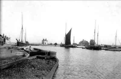
(above) the 'Eel company's' live eels wet hold storage
barge 'Gerhard' is waiting in the lock to be loaded from a ship
outside in the Reach. Brown's shed and barges loaded with timber
are in the background. |
|
|
It was during this time
that another business venture moved to the Basin .... the importation
and distribution of live eels by Hans
Kuijton. Hans had operations in England, Ireland, Holland
and as far away as New Zealand. He built a warehouse with offices
attached beside Lock Hill and brought in several floating storage
barges. An interview with Hans revealed that unfortunately threats
and blackmail from the IRA in Ireland resulted in Hans closing
the business down. Brown's eventually
stopped bringing timber to the Basin in 1972, and with the destruction
of their large storage building by the great gale of 1989, all
signs of them having operated in the Basin were gone. |
 |
|
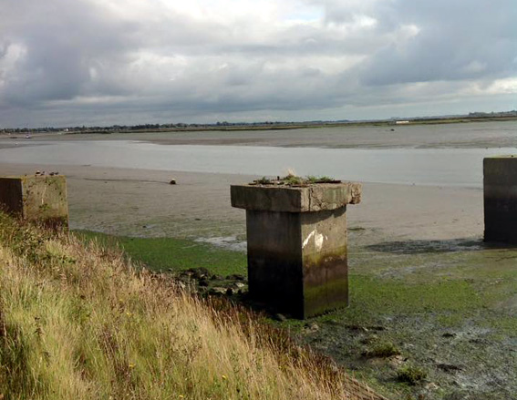
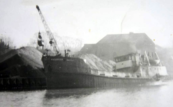
(above) all that remains of the 'Brush
Aggregates' gravel business operated from 'Herring's Point',
is the blocks that the crane for loading was mounted on. 08 (below)
the 'Maureen Brush' ex 'Bill Brush' a regular visitor to the
Basin for aggregates. |
 |
|
|
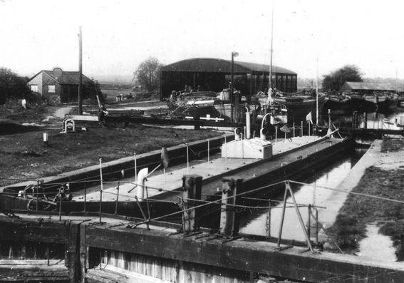
During the 1960's a sand
and gravel business was operated from the area behind the current
Lockhouse. A large pit was dug for the removal of the gravel
by 'Brush Aggregates Ltd', and loaded
on to coasters by a crane permanently mounted on blocks at 'Herring's
Point'. It should be noted here that the name 'Herrings Point'
had no relevance to the fish of the same name. The residence
nearby of Heybridge Hall was occupied for many years by the Reverend
Herrings. |
 |
|
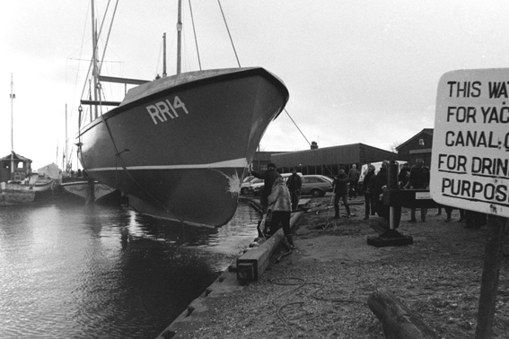
(above) 'Hartley & Brookes'
boatbuilders launching a newly built fishing vessel, one of many
built in their two yards by the Basin. |
|
|
Several business established
themselves along the side of the canal and Basin, the largest
being run by Colin Brookes designing and building boats, under
the name of 'Hartley & Brookes'
from the two yards known as the 'Top & Bottom' yards and
the office block originally built for the old 'Eel
Company'. After the closing down of the two main businesses
'May & Butcher' and
'Blackwater Timbers' the village
dramatically increased in size with new residential developments.
Then with the moving away of the boatbuilding business of 'Hartley & Brookes' and most
of the remaining small businesses during the early 90's, the
village as well as the Basin and canal transformed for the first
time to just a residential and leisure area, save for the activities
of Stewart Tolfrey, and
the two boat yards with moorings of Stebbens
and Arthur Holt along the waterfront. |
|
|
In conclusion .... the
largest activity outside of residential use of the village is
now the 'Outdoor Activities Centre'
of the London Borough of Newham. |
 |