|
Heybridge Basin (Cannibal
Island) |
|
|
Click
on underlined blue names for link to more details |
|
|
The
Village Tour |
|
Page
One |
|
|
 |
|
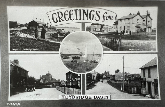
(above) a multi postcard
from the 1930's |
|
|
To get an idea of how the village
has developed over time, it is necessary to consider where the
village originally began. The road from the 'tollgate' has been
variously recorded as 'Borough Road', 'Boro Road and 'Barrow
Road', the latter most likeley being correct. The road was defined
in two sections under the 'Enclosures Act' of the 7th December
1815. This road ran from the 'toll-gate' as far as what is now
(Tinkers) No81 Basin Road. This property was originally No1 Basin
Road until the postal changes in the the 80's. It was at this
point that the village began (the second section) and the road
name changed to 'Basin Road'. To elaborate on this, the first
group of houses on the left had their numberings changed in the
1980's and updated to match the present length of Basin Road.
'Tinkers' cottage was No1, 'Darby' & Janet Stebbens house
was No2, Nigel & Jean Willmott's house was No3, Colin &
Nanette Brookes' house (River Cottage) was No4, Tony Collett's
house (Ivy Cottage) was No5, Tom & Sue Polden's house (Pilot
Cottage) was No6 etc etc. When re-numbered Tom and Sue Polden's
house became No91. |
|
Stories abound around
the removal of the toll to use the road to the village, but it
was defined as a public access road in the 'Enclosures Act' of
the 7th December 1815. The Salt Company already had access direct
from Goldhanger Road where the 'Salcott' cottages are, and most
villagers used the canal towpath or Tovee's lane for access to
Heybridge and Maldon. |
|
Again there are many and
various stories about the earliest and subsequent sequence of
buildings being erected in the village, but we do know for sure
is that Mr Tovee was residing in a house with a salt business
in an area behind what is now the current Lock Keepers house
before the canal was built, and that the first dwelling built
and used by the first Lock Keeper and Superintendant was approximately
in the area of the garden next to where the Eel Company's offices
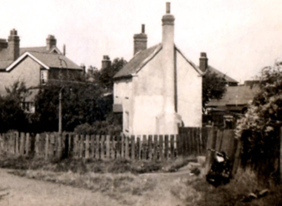
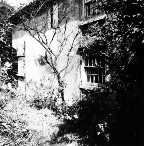
were built. A picture below is of it while in the occupation
of the Munro family. Prior to that it was occupied by the Willis
family and last of all by the Clark family, which sadly during
their occupation it was burnt down. Tom Warraker also had an
early salt business, it was either seperate or a possibility,
that it was originally Tovee's as the latter had become very
involved in early canal activities right from the offset. |
 |
|
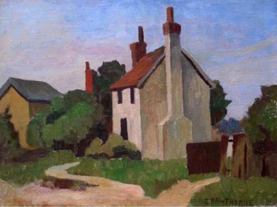
(above and below) the
first house known to have been built in the village plus a painting
of it. Pictures late 1930's. |
 |
 |
|
|
It is believed that the
first land leased from the Canal Company was by Tovee who built
the group of three cottages next to the lock (Nos 1 to 3 Lock
Hill) and opened the end one as a beerhouse called the 'Chelmer
Brig', (this does not include the building on the corner which
was built later and is now called 'The Old Ship'). |
|
For the first few years
the village was very small consisting of just an area from the
side of the canal Basin to where Kedge Cottage now stands, with
access from either round the front by the sea-wall as it is now,
or direct via a lane which is now the passageway starting near
the car-park corner. This lane which led up to the canal passed
a small group of three cottages on the left, the cottage in the
picture above behind them from a junction half way, ending up
next to the Granary storage warehouse by the canal. For ease
of description throughout this website and because it was what
some of us later called it unofficially, it will be called 'Two
Ways Lane'. Likewise the lane beside 'The Exchange', is called
'Chapel Lane'. The lane alongside the lock and Basin from the
sea-wall, including the two yards and building of the Eel Company,
is known as 'Lock Hill'. And the 'Blackwater & Chelmer Navigation
Company' will be referred to as 'the Canal Company'. |
 |
|
(above
& below) the group of three cottages
in 'Two Ways' at about the place where 'Kedge Cottage' is now. |
 |
|
|
(above) In this first group of building the only ones being
used commercialy were the 'Granary', and the end cottage of the
group of three (No1 Lock Hill), called the 'Chelmer Brig', which
was run by Richard Tovee. |
 |
|
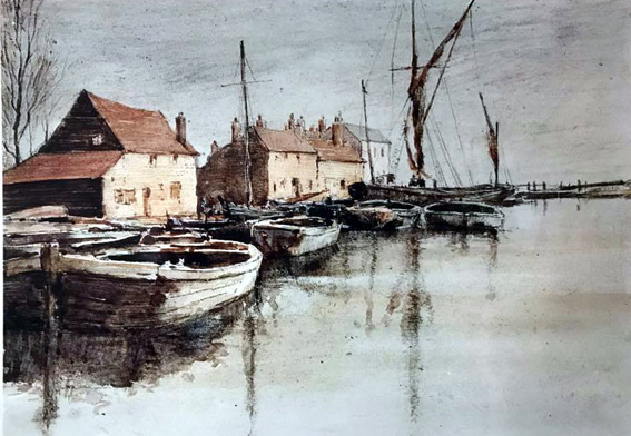
04 (above) an early painting
of the area alongside the canal Lock and Basin, showing the Granary
on the left and the row of two groups of cottages from the earliest
time. The building on the corner which is now 'The Old Ship'
having been built later. |
|
|
As was often the
case in an English country village there were nicknames for the
many places about or round the vicinity of the village, and the
'Basin' as it was known was no different. 'Daisy Meadows' where
the the car park now stands and the 'Bullock or Cow Fields' between
the style near the village pond and the Blackwater Sailing Club.
The gate near the car park was 'Chalk Heap Gate', and by 'Daisy
Meadows' it was the 'Great Gate'. The little channel through
the mud up to the outer lock gate was called 'The Gutway or Cutway',
and had 'withey's', made from Willow branches stuck in the mud
for guidance. |
|
The village has had two
ponds over the years, one in front of where St George's Church
was put, and another behind the row of cottages opposite 'Spray
Cottage', which was part of the 'May & Butcher' yard for
many years. |
 |
|
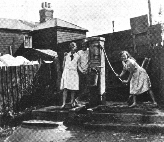
(above) one of the village
pumps, in front and beside what was the 'Eel Company's' offices.
Winifred Hopper is on the pump handle. |
|
|
There were four pumps
in the village and an artesian well behind Ivy/Pilot Cottages.
One pump was down by the front of the old 'Eel
Company' building which would naturally have been originally
in front of the oldest house. It was said that when the well
at Osea was dug it dried up the Basin wells. |
|
|
 |